Monday, July 3, 2017

Dan Hinkley's Interesting Conjecture


At risk of offering a suggestion that has more than likely already been examined as obvious, the photos in your blog appear as if we might be dealing with a mycelium complex in the soil that has made the edaphic environment hydrophobic.

It appears as if nothing is regenerating, making it seem evident that the pathogen is not conspecific to Polystichum but simply establishing in Polystichum-friendly habitat. 

Have any observations been made of fungal fruiting bodies on the outer edge of the infection sites or have soil samples been examined for the presence of mycelia?  This has the gestalt of a ‘fairy ring’ in a lawn.  Has anyone attempted to mechanically aereate the Hatchery Creek site to see if something will again begin to grow?  The dead zone can seemingly only point to a hydrophobic condition, or to an unlikely pathogen that kills everything in its wake and disallows anything to reestablish.
Port Ludlow report by Jim Gormly

Beyond Kitsap Peninsula, across the Hood Canal, there is a greenbelt in Port Ludlow, ca. 2000x400 feet. It is a second-growth forest primarily with western red cedar, douglas fir and large-leaf maple trees. It is mostly shaded, but there is the occasional small open area free of trees. The understory is mainly sword fern, salmon berry, blackberry and other nasty vines. Apparently, a few years ago a beetle infestation caused the death of a large number of alders.

Yesterday I became aware of an area, perhaps 75x25 feet rectangle of dead ferns. I estimate that more than 50 plants were obvious. Since I don't know how the problem is transmitted, I chose not to be a vector, just in case it might be a spore transfer, so I didn't climb in to get a more accurate number of dead ferns. Throughout the greenbelt, there is the occasional dead or dying fern, but this is clearly the largest concentration I observed. There was also a dying salal plant among the cluster of dead ferns (see photo). I'm sorry the exposure is not the best.

When I saw the dead ferns, my first reaction was that someone dumped a herbicide, but that made no sense, so I did a Google search and found your blog. I must say that this is very disconcerting. I hope you find a solution. I will continue to monitor here, and will update you as time passes. . We have extensive greenbelts here with trails through them, and many residents enjoy walking the trails. It would be a sad loss if the apparent trend continues. 


Jim Gormly

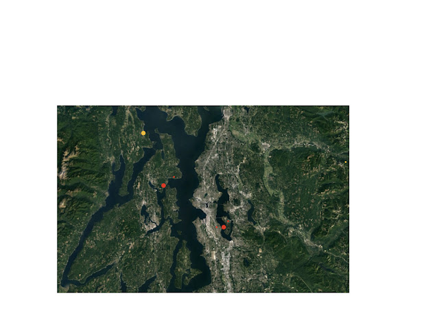
Regional Map (Verified and Candidate Sites)

An informal regional Puget Sound map, with dots showing verified and candidates die-off sites, size and color a very rough indicator of status and severity.  Small, unverified sites may not stand up to scrutiny.
  • Seward Park (first reported 2014, 15 acres, verified, spreading)
  • Suquamish (2010,  2 acres, verified, spreading)
  • Indianola (2017, < 0.1 acres, not yet visited)
  • Cheasty Mountain View (2017, 0.5 acres, verified, spread status unknown)
  • Mercer Island Upper Luther Burbank Park (2016, < 0.1 acres, verified, spread status unknown)
  • Port Ludlow ( 2017,  < 0.1 acres, not yet visited)
  • Baring (2017, < 0.1 acres, not yet visited)